53街 53rd Street | |||||||||||||
|---|---|---|---|---|---|---|---|---|---|---|---|---|---|
.jpg) 北行R线列车抵达月台 | |||||||||||||
| 位置 | 纽约州纽约市布鲁克林区53街及第四大道 | ||||||||||||
| 镇区 | 布鲁克林 | ||||||||||||
| 区域 | 日落公园 | ||||||||||||
| 地理坐标 | 40°38′37″N 74°0′55.86″W / 40.64361°N 74.0155167°W | ||||||||||||
| 车站类别 | 纽约地铁车站 | ||||||||||||
| 途经线路 | |||||||||||||
| 轨道线路 | BMT第四大道线 | ||||||||||||
| 系统 | B系统(BMT) | ||||||||||||
| 换乘交通 | |||||||||||||
| 车站构造 | |||||||||||||
| 站体类型 | 地下 | ||||||||||||
| 出口数目 | 第四大道及53街、第四大道及52街(只限南行) | ||||||||||||
| 建筑设计 | |||||||||||||
| 股道 | 4条 | ||||||||||||
| 其他信息 | |||||||||||||
| 车站代码 | 034[1] | ||||||||||||
| 历史 | |||||||||||||
| 启用日期 | 1915年6月22日[3] | ||||||||||||
| 关闭日期 | 2017年3月27日(重建) | ||||||||||||
| 重建日期 | 2017年9月8日 | ||||||||||||
| 营运信息 | |||||||||||||
| 乘客数量 (2016) | 2,334,471[4] ▼ 1.7% | ||||||||||||
| 排行 | 216/422 | ||||||||||||
| 下一站 | |||||||||||||
| 北向 | 45街:N | ||||||||||||
| 南向 | 59街:N | ||||||||||||
| |||||||||||||
53街车站(英语:53rd Street station)是纽约地铁BMT第四大道线的一个慢车地铁站,位于布鲁克林日落公园53街及第四大道交界,设有R线(任何时候停站)、W线(仅繁忙时段停站)、N线(仅深夜停站)列车服务[5][6]。
历史

此站在1915年6月22日作为BMT第四大道线前往59街原初路段启用。59街车站是此站的南邻车站[3]。
1970年代末车站进行了翻新。旧的裁切线由白色煤渣砖取代,只有墙壁上的小型凹槽是蓝色煤查砖。翻新时维修了楼梯和安装了新的月台边。蓝色煤查砖包括站名牌和出口指示牌。翻新同时将白炽灯更换为萤光灯。
车站重建
在2015-2019年MTA资金计划,车站与其他三十个纽约地铁车站进行翻新,并关闭5个月。更新内容包括蜂窝服务、Wi-Fi、充电站、改善指示牌、改善车站灯光[7][8]。2016年1月至5月,格林沙尔建筑工作时车站翻新设计,阿鲁普集团作为咨询。翻新合约包括翻新BMT第四大道线上的展望大道、53街及湾脊区大道车站,在2016年11月30日获得合约[9]。Citnalta-Forte联合投标获选在这三个车站进行7200万美元设计兴建合约的翻新,是纽约地铁历史上首次类似的合约[10]。2017年3月27日关闭进行翻新[11][12][13]并在2017年9月8日重开[14],比预期提早[15]
车站结构
| G | 街道层 | 出入口 |
| M | 夹层 | 闸机、车站询问处 |
| P 月台层 |
侧式月台,右侧开门 | |
| 北行 | ||
| 北行快速 | ||
| 南行快速 | ||
| 南行 | ||
| 侧式月台,右侧开门 | ||
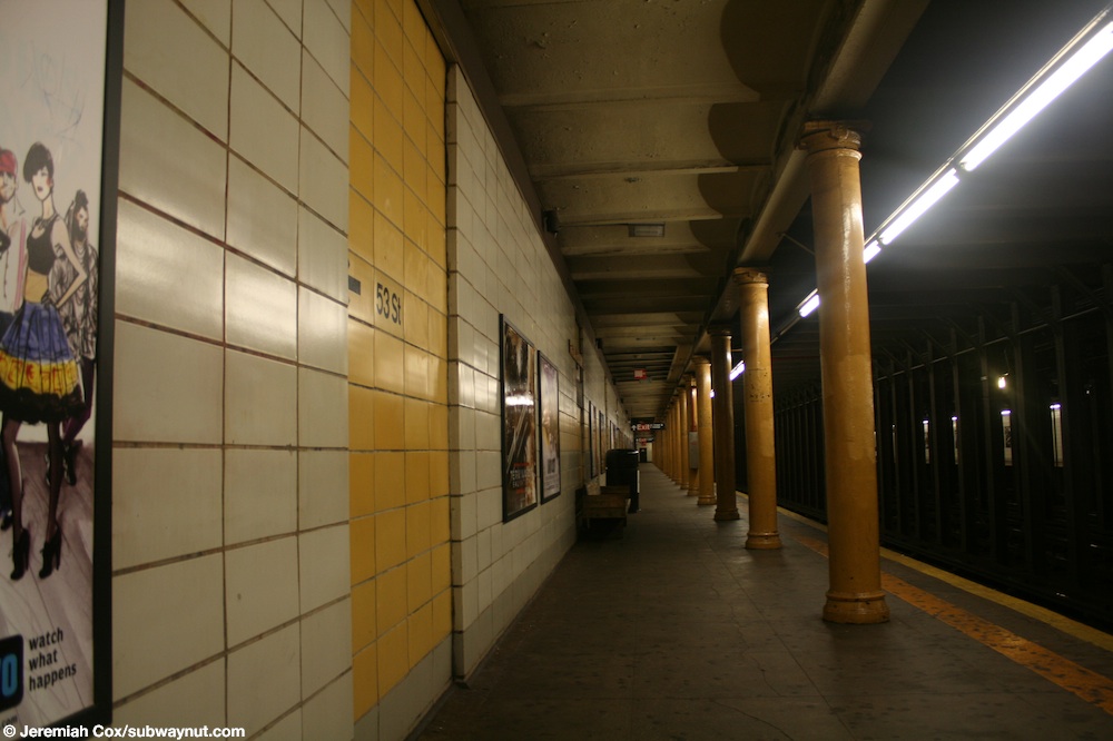
此地下车站设有两个侧式月台和四条轨道[16]两条中央轨道在日间由N线列车使用[5]。车站墙壁包括翻新的煤渣砖(主要为白色,少量带有黑色砖)、黑白站名牌以及萤光灯。2017年翻新加入了符合美国残疾人法案的月台踏板和灰色地砖地板,以及车站墙壁上方的间接照明,由月台边缘上方移动。
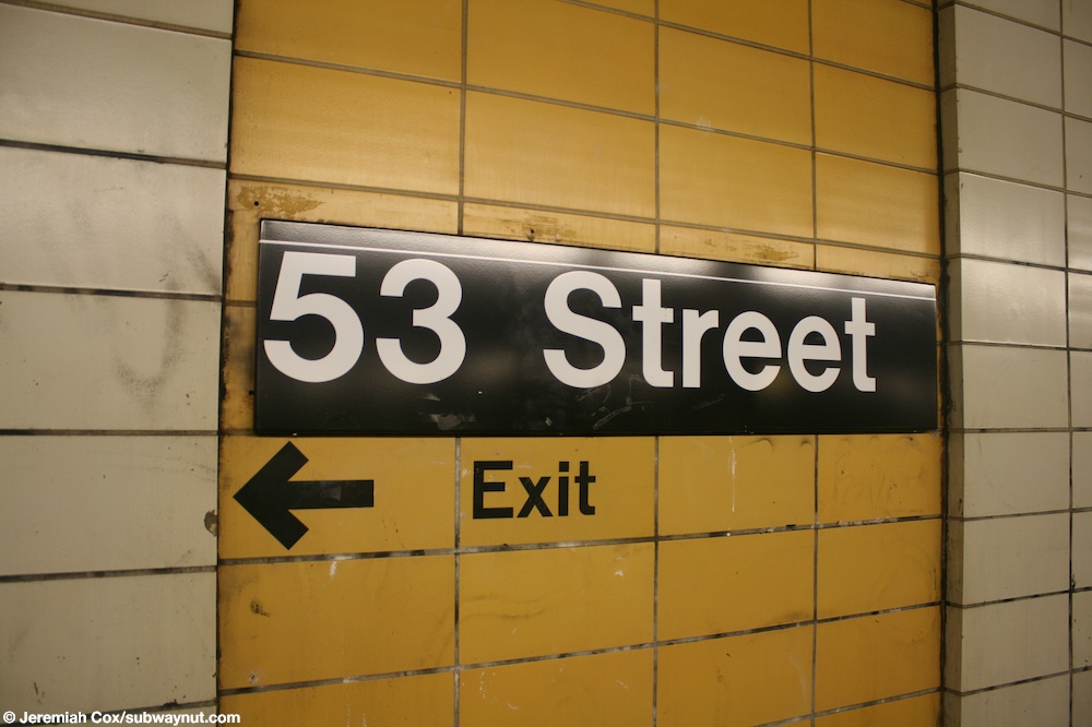
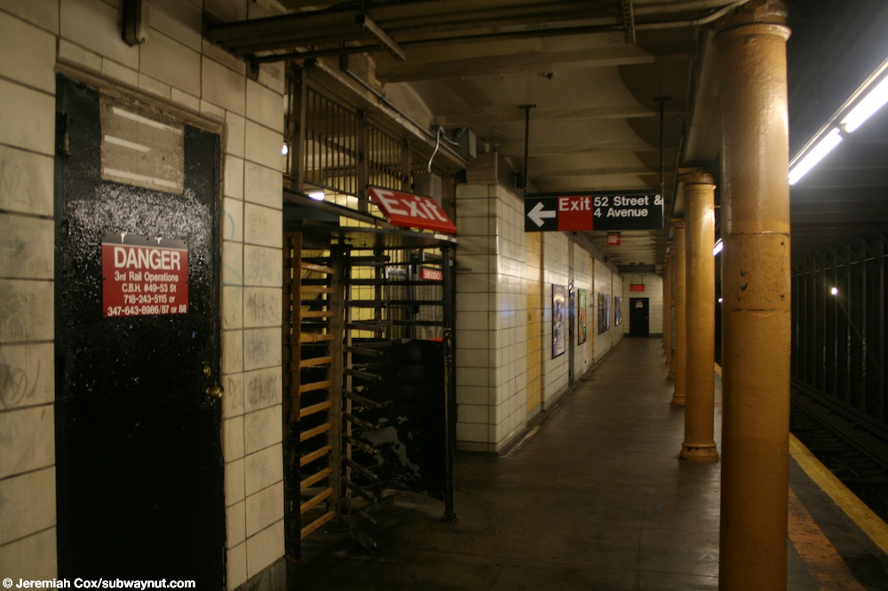
月台上,路牌和往出口的箭头印在白色墙砖上[17][18]。两个月台的梁柱都髤上黑色[19]。每隔一柱就在黑底白字的“53街”站名牌[20]。几乎全部梁柱都是圆柱,只有近车站主入口两条楼梯的梁柱因位于月台延长处而是方形[19]。
此站的2017年艺术品由居住在布鲁克林的艺术家麦卡连·汤马斯设计的启发自大自然的马赛克[14]。
出口
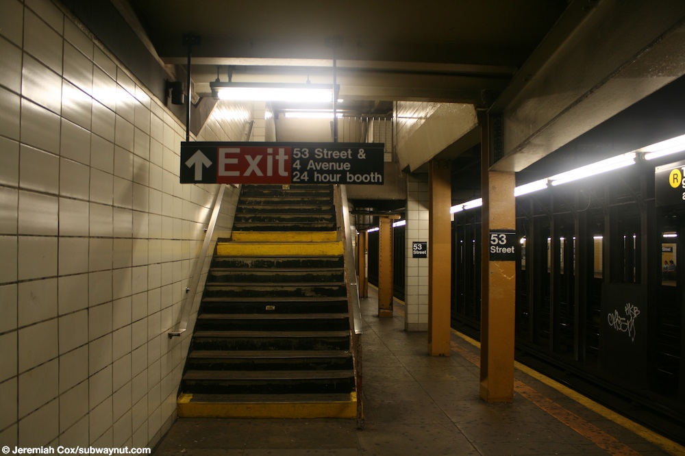
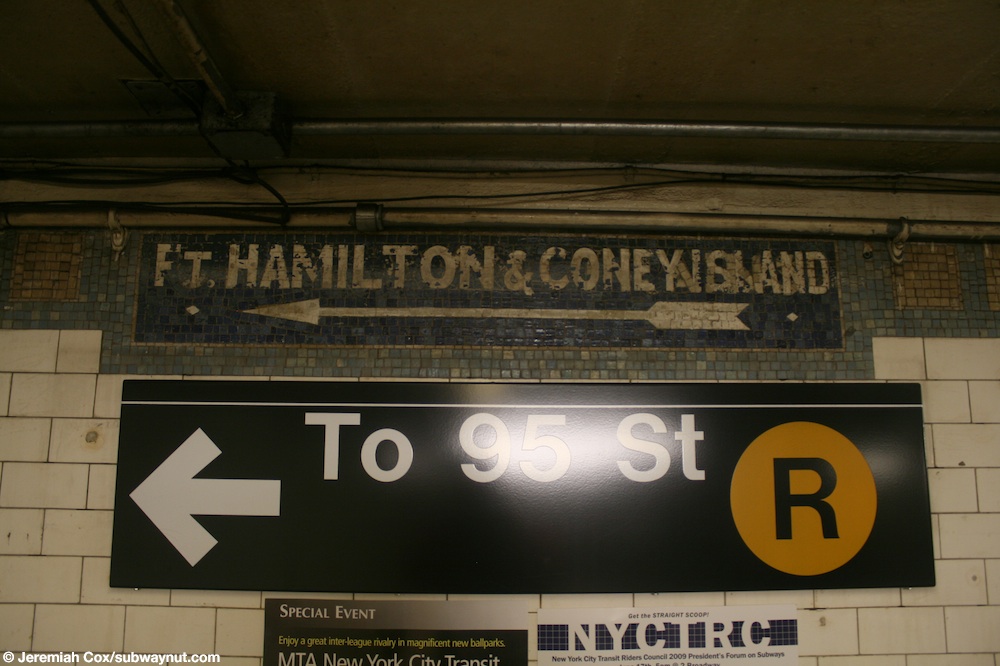
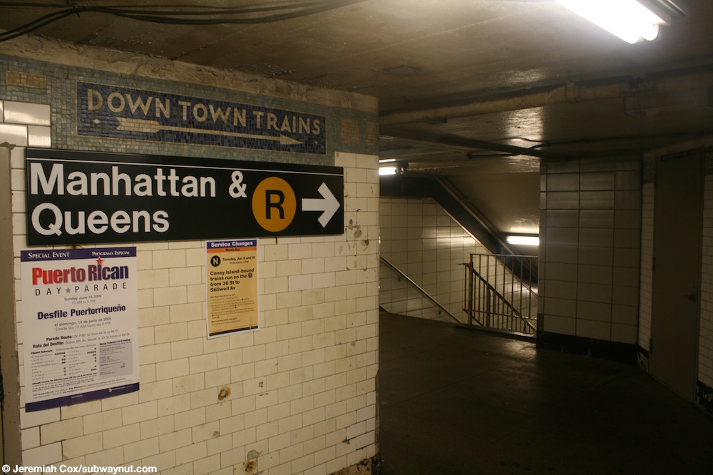
车站的主入口设有两条楼梯往各月台,往第四大道和53街的西北角和东北角各一条。夹层容许坐回头车,并设有原初的马赛克箭头标志[21][22]。南行月台楼梯旁显示“汉密尔顿堡及康尼岛”,而往曼哈顿方向月台楼梯则显示“市中心列车”[23][24]。
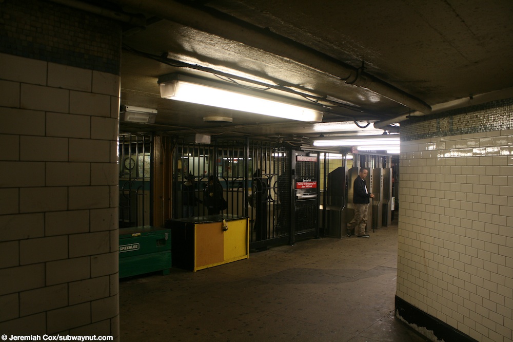
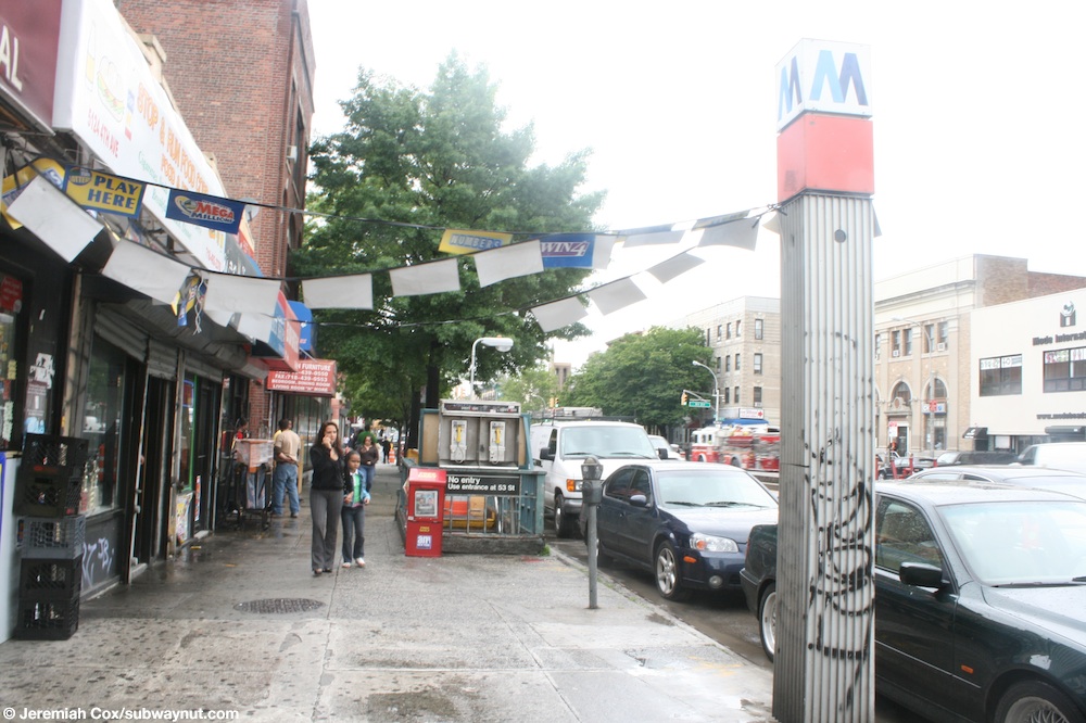
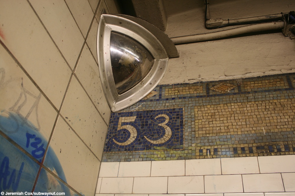
南行月台近北端还有额外入口[25]。两部月台层的闸机前往一个著陆层,之后再有三级楼梯上到52街和第四大道交界。2017年翻新以前,这个入口只出不入[22][26]。著陆层包括原先1915年修剪线,以及车站翻新前的“53”字样[27]。


.jpg)
参考资料
- ↑ Station Developers' Information. Metropolitan Transportation Authority. [2017-06-13].
- ↑ "NYC Subway Wireless – Active Stations". Transit Wireless Wifi. Retrieved 2016-05-18.
- ↑ 3.0 3.1 Through Tube to Coney, 48 Minutes: First Train on Fourth Avenue Route Beats West End Line Eleven Minutes. Brooklyn Daily Eagle. 1915-06-22 [2015-06-29] –通过Newspapers.com.
- ↑ Facts and Figures: Annual Subway Ridership 2011–2016. Metropolitan Transportation Authority. 2017-05-31 [2017-06-01].
- ↑ 5.0 5.1 N Subway Timetable, Effective 2017-01-01 (PDF). New York Metropolitan Transportation Authority. [2016-12-28].
- ↑ R Subway Timetable, Effective 2016-11-07 (PDF). New York Metropolitan Transportation Authority. [2016-12-28].
- ↑ MTA Will Completely Close 30 Subway Stations For Months-Long "Revamp". Gothamist. 2016-01-08 [2016-07-18].
- ↑ MTAStations (PDF). governor.ny.gov. Government of the State of New York. [2016-07-18].
- ↑ Capital Program Oversight Committee Meeting (PDF). mta.info. Metropolitan Transportation Authority. 2016-11 [2016-11-27].
- ↑ Three Brooklyn R Stations are First in Major Subway Station Modernization Project. Metropolitan Transportation Authority. 2017-03-22 [2017-08-31].
- ↑ Spivack, Caroline. Shuttle scuttle: Riders demand extra buses during three subway stations’ closure. Brooklyn Paper. 2017-01-16 [2017-01-27] (英语).
- ↑ MTA will close these Brooklyn subway stops to facilitate upgrades. Curbed NY. 2017-03-22 [2017-03-24].
- ↑ Trains skip 53 St in both directions. web.mta.info. Metropolitan Transportation Authority. 2017-03-26 [2017-03-26].
- ↑ 14.0 14.1 DeJesus, Jaime. Sunset Park’s renovated 53rd Street station is open for business. Brooklyn Reporter. 2017-09-08 [2017-09-08] (美国英语).
- ↑ Newly renovated R train subway station transforms into commuter dream with USB ports, countdown clocks. New York's PIX11 / WPIX-TV. 2017-09-09 [2017-09-10].
- ↑ Dougherty, Peter. Tracks of the New York City Subway 2006 3rd. Dougherty. 2006 [2002]. OCLC 49777633 –通过Google Books (英语).
- ↑ Cox, Jeremiah. A 53 Street platform sign, text and a arrow for 52 St is painted beneath this one.. subwaynut.com. 2009-06-09 [2017-03-26].
- ↑ Cox, Jeremiah. A 53 Street platform sign, text and a arrow for 52 St is painted beneath this one.. subwaynut.com. 2009-06-09 [2017-03-26].
- ↑ 19.0 19.1 Cox, Jeremiah. A final view down the Bay Ridge-bound side platform with its narrow columns at 53 Street.. subwaynut.com. 2009-06-09 [2017-03-26].
- ↑ Cox, Jeremiah. A staircase up to the small mezzanine area and fare control form the Bay Ridge-bound platform at 53 Street.. subwaynut.com. 2009-06-09 [2017-03-26].
- ↑ Cox, Jeremiah. Looking back towards the entrance turnstiles on the mezzanine level at 53 Street.. subwaynut.com. 2009-06-09 [2017-03-26].
- ↑ 22.0 22.1 MTA Neighborhood Maps: Sunset Park (PDF). mta.info. Metropolitan Transportation Authority. 2015 [2015-08-02].
- ↑ Cox, Jeremiah. A unique mosaic says Ft. Hamilton & Coney Island and points towards the platform To 95 Street at 53 Street.. subwaynut.com. 2009-06-09 [2017-03-26].
- ↑ Cox, Jeremiah. The passageway that leads to the two staircases down to the Down Town Trains platform at 53 Street.. subwaynut.com. 2009-06-09 [2017-03-26].
- ↑ Cox, Jeremiah. Another view approaching the High Exit Gate that leads to 52 St.. subwaynut.com. 2009-06-09 [2017-03-26].
- ↑ Cox, Jeremiah. A M subway entrance column with red on it on 4th Avenue, and the No Entry staircase down to the exit from 52 Street.. subwaynut.com. 2009-06-09 [2017-03-26].
- ↑ Cox, Jeremiah. The only 53 tiling in the single band of trim that is still visible after passing through the High Exit gate that leads out to 52 St.. subwaynut.com. 2009-06-09 [2017-03-26].
外部链接
| 外部视频链接 | |
|---|---|
- * nycsubway.org—BMT 4th Avenue: 53rd Street
- Station Reporter — R Train
- The Subway Nut — 53rd Street Pictures
- Rebuilt Platforms from Google Maps Street View
- Rebuilt Mezzanine from Google Maps Street View
- Rebuilt 53rd Street Entrance from Google Maps Street View