
原始文件 (2,987 × 3,967像素,文件大小:2.62 MB,MIME类型:image/jpeg)
| 描述 |
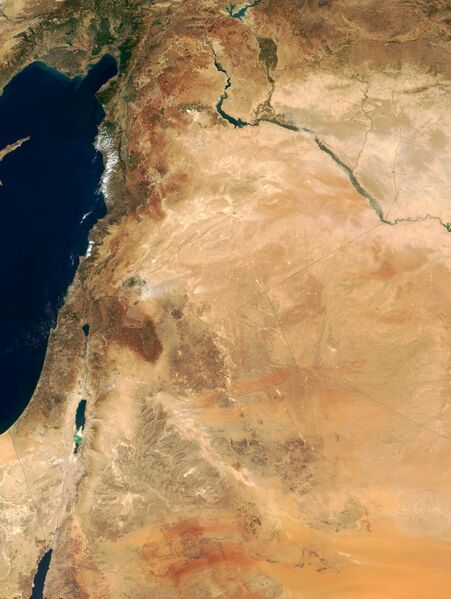
This true-color image of the region was taken on September 10, 2000, by the MODerate-resolution Imaging Spectroradiometer (MODIS) flying aboard NASA's Terra spacecraft. The image shows the lands of Israel along the eastern shore of the Mediterranean Sea, with the countries of Jordan to the southeast and Syria to the Northeast. Jerusalem is Israel's capital city and Amman is the capital of Jordan. The region known as the West Bank lies between the two countries. Running from north to south, the Jordan River links the Sea of Galilee to the Dead Sea. Click the image to enlarge it, and to see the borders drawn in. Image courtesy Jacques Descloitres, MODIS Land Group, NASA GSFC |
| 日期 | image taken on 10. Sep. 2000 |
| 来源 | http://earthobservatory.nasa.gov/Newsroom/NewImages/Images/modis_near_east_lrg.jpg |
| 作者 | NASA, earthobservatory, http://earthobservatory.nasa.gov/ |
| 许可 (二次使用本文件) |
PD-USGov-NASA |
本作品是完全由美国国家航空航天局(NASA)创作,或由其雇员以个人公务目的创作;根据NASA的版权方针及美国法典第17篇第1章第105条(17 U.S. Code § 105),本作品在美国属于公有领域。
- NASA的标志、徽章、徽标等受到美国联邦法规第14篇第1221部分(14 CFR 1221)的限制。
- NASA网站上的苏联、俄罗斯或其他非美国航天机构的图片,通常不属于公有领域。
- 根据哈勃空间望远镜的数据制作的材料,若未明确声明由STScI提供,则可能受到版权保护。
- SOHO(ESA和NASA)联合项目表示,由旗下的探测器创作的材料受版权保护,且对于商业性非教育目使用材料需要授权。
- 每日一天文图(APOD)网站上展示的图片可能受到版权保护。
- 美国国家太空科学数据中心(NSSDC)网站存储了受版权保护内容;尽管如此,除非另有声明,图库的所有图片都属于公有领域。
- 来自喷气推进实验室(JPL)的文件,应注明来自“NASA/JPL”或“NASA/JPL-Caltech”,参见JPL图像使用政策。

文件历史
点击某个日期/时间查看对应时刻的文件。
| 日期/时间 | 缩略图 | 大小 | 用户 | 备注 | |
|---|---|---|---|---|---|
| 当前 | 2023年8月19日 (六) 09:19 | | 2,987 × 3,967(2.62 MB) | BXHS-bot(留言 | 贡献) | 自其他网站迁移文件 |
您不可以覆盖此文件。