
原始文件 (3,240 × 1,903像素,文件大小:2.01 MB,MIME类型:image/jpeg)
本文件可使用矢量图形格式重新绘制。若此图片存在SVG格式版本,请其上传,然后在本页面插入下列代码:模板链接:{{vector version available|新图片名称}}。
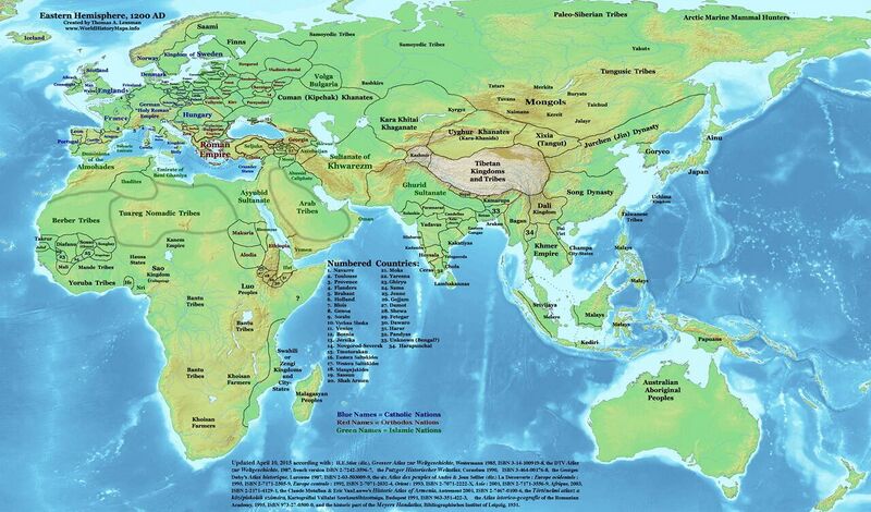
| 描述 | Eastern Hemisphere in 1200 AD. |
| 来源 | self-made (For reference information, see the Map Source References section below.) |
| 作者 | Thomas Lessman |
| 许可 (二次使用本文件) |
本作品著作权人,特采用下列许可条款发表本作品: 本文件采用知识共享署名-相同方式共享 3.0 未本地化版本(CC BY-SA 3.0)许可协议授权。
|
| 其他版本 | see East-Hem_1200ad.jpg file history on Wikipedia. |
Map Summary
Original Source URL: http://www.thomaslessman.com/History/images/East-Hem_1200ad.jpg.
This map of the Eastern Hemisphere in 1200 AD was created by Thomas Lessman, based on information from the sources listed below. This map is free for educational use (see Permission info above). When using this map, please mention that it is available for free at www.WorldHistoryMaps.info. Derivative work updated April 10, 2015 by little changes according with : H.E.Stier (dir.), Grosser Atlas zur Weltgeschichte, Westermann 1985, ISBN 3-14-100919-8, the DTV Atlas zur Weltgeschichte, 1987, french version ISBN 2-7242-3596-7, the Putzger Historischer Weltatlas, Cornelsen 1990, ISBN 3-464-00176-8, the Georges Duby’s Atlas historique, Larousse 1987, ISBN 2-03-503009-9, the six Atlas des peuples of André & Jean Sellier (dir.) La Découverte : Europe ocidentale : 1995, ISBN 2-7171-2505-9 模板链接:{{ISBN}}参数错误:ISBN无效。, Europe centrale : 1992, ISBN 2-7071-2032-4, Orient : 1993, ISBN 2-7071-2222-X, Asie : 2001, ISBN 2-7171-3556-9 模板链接:{{ISBN}}参数错误:ISBN无效。, Afrique, 2003, ISBN 2-2171-4129-1 模板链接:{{ISBN}}参数错误:ISBN无效。, the Claude Mutafian & Eric VanLauwe’s Historic Atlas of Armenia, Autrement 2001, ISBN 2-7467-0100-6, the Történelmi atlasz a középiskolák számára, Kartográfiai Vállalat Szerkesztőbizottsága, Budapest 1991, ISBN 963-351-422-3, the Atlas istorico-geografic of the Romanian Academy, 1995, ISBN 973-27-0500-0, and the historic part of the Meyers Handatlas, Bibliographisches Institut of Leipzig, 1931.
Map Source References
- Remember, sources often conflict with each other. This map is only as accurate as the information that is available to me. To report any errors or to help further this work, please Talessman#Corrections and Project Help, or email Thomas Lessman at talessman@yis.us
References for information contained in this map:
1. Borders of Europe are mostly derived from the "Euratlas.com" map of Europe in 1200 AD.
- (Please note: Bogomolov.PL has done a great job of showing me possible discrepancies in my north European borders compared to this source, due to the differences in the geographical layout of the maps.) See this talk page for more info.
2. The DK Atlas of World History, 2000 Edition; map of The World in 1200 AD (Pages 62-63) was also used to add additional information to this map.
3. Fringe areas like Africa, Australia, Siberia, etc. derive from various Wikipedia articles.
4. Much of the information in this map was cross-checked with Bruce Gordon's Regnal Chronologies.
5. Borders of Asian countries derive from various Wikipedia articles and Google history map searches.
Other Maps by Thomas Lessman
文件历史
点击某个日期/时间查看对应时刻的文件。
| 日期/时间 | 缩略图 | 大小 | 用户 | 备注 | |
|---|---|---|---|---|---|
| 当前 | 2023年9月15日 (五) 17:15 | | 3,240 × 1,903(2.01 MB) | BXHS-bot(留言 | 贡献) | 自其他网站迁移文件 |
您不可以覆盖此文件。